Trail Via ferrata Le Monêtier-les-Bains - Via ferrata Aiguillette du Lauzet 30/06/18 - Photo

Via ferrata Aiguillette du Lauzet 30/06/18

 R@ph
R@ph

User GUIDE

© OpenStreetMap contributors
Length
Length
9.5 km
Max alt
Max alt
2585 m
Uphill gradient
Uphill gradient
849 m
Km-Effort
Km-Effort  
21 km
Min alt
Min alt
1711 m
Downhill gradient
Downhill gradient
883 m
Boucle
Boucle
Yes
Creation date :
2018-06-30 17:42:13.922
Updated on :
2018-07-01 06:10:52.383

(0 Reviews)

Via ferrata
Via ferrata
2h30
Difficulty : Medium

Scan this QR Code to open this trail in the SityTrail application

FREE GPS app for hiking

Logo SityTrail SityTrail

IGN / Geographical institutes

Download SityTrail from the App Store Download SityTrail from Google Play

Logo SityTrail SityTrail World

The world is yours!

Download SityTrail from the App Store Download SityTrail from Google Play Download SityTrail on Huawei AppGallery

About

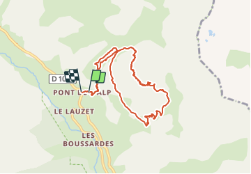
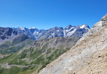
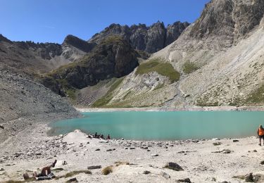
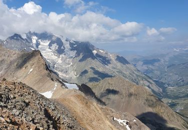
Trail Via ferrata of 9.5 km to be discovered at Provence-Alpes-Côte d'Azur, Hautes-Alpes, Le Monêtier-les-Bains. This trail is proposed by R@ph.

Description

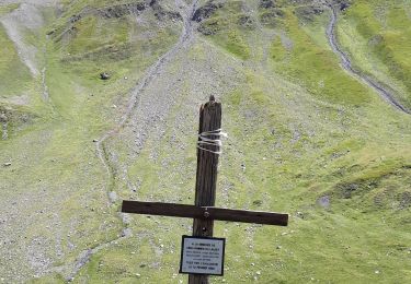
Au départ du pont de l'Alp, une marche d'approche d'environ 45mn pour accéder au départ de la via Ferrata. Très belle via, avec un très bon contact avec le rocher, peu de ferraillage, juste le nécessaire. Une première partie plutôt horizontale, puis après le petit tunnel on passe plus en verticalité et une sortie au sommet de l’aiguillette superbe. Attention à ne pas rater le tout dernier tronçon de via qui permet justement de sortir au sommet.
Une bonne heure et demie de marche pour revenir au point de départ.

Elevation profile

Photos

Positioning

Country:
France
Region :
Provence-Alpes-Côte d'Azur
Department/Province :
Hautes-Alpes
Municipality :
Le Monêtier-les-Bains
Location:
Unknown
Start:(UTM)
300476 ; 4988080 (32T) N.

Trails nearby

Trail Walking Le Monêtier-les-Bains - Le Grand Lac - Photo
Walking
tracegps

Walking

Difficult
(2)
Le Monêtier-les-Bains, Provence-Alpes-Côte d'Azur, Hautes-Alpes, France
5.2 km | 12.8 km-effort
5h 0min
No
Trail Touring skiing Le Monêtier-les-Bains - La pointe de L'etandard - Photo
Touring skiing
GUIDE
nadd73

Touring skiing

Medium
Le Monêtier-les-Bains, Provence-Alpes-Côte d'Azur, Hautes-Alpes, France
9.4 km | 27 km-effort
4h 3min
Yes
Trail Touring skiing Villar-d'Arêne - Roc noir de Combeynot - Photo
Touring skiing
GUIDE
nadd73

Touring skiing

Medium
Villar-d'Arêne, Provence-Alpes-Côte d'Azur, Hautes-Alpes, France
8.2 km | 19.6 km-effort
3h 5min
No
Trail Walking Le Monêtier-les-Bains - 05 col ponsonniere - Photo
Walking
GUIDE
randodyssée

Walking

Medium
Le Monêtier-les-Bains, Provence-Alpes-Côte d'Azur, Hautes-Alpes, France
14.4 km | 27 km-effort
6h 25min
No
Trail Walking Le Monêtier-les-Bains - Pic Blanc du Galibier - Photo
Walking
GUIDE
amiral13

Walking

Medium
Le Monêtier-les-Bains, Provence-Alpes-Côte d'Azur, Hautes-Alpes, France
4.3 km | 9.9 km-effort
2h 51min
Yes
Trail Walking Névache - Beraudes  - Photo
Walking
GUIDE
jouans

Walking

Medium
Névache, Provence-Alpes-Côte d'Azur, Hautes-Alpes, France
11.1 km | 22 km-effort
6h 33min
No
Trail Walking Le Monêtier-les-Bains - pic est de Combeynot - Photo
Walking
GUIDE
amiral13

Walking

Very difficult
Le Monêtier-les-Bains, Provence-Alpes-Côte d'Azur, Hautes-Alpes, France
13.3 km | 33 km-effort
6h 24min
Yes
Trail Walking Le Monêtier-les-Bains - l'aiguillette du Lauzet par le grand lac - Photo
Walking
GUIDE
amiral13

Walking

Difficult
Le Monêtier-les-Bains, Provence-Alpes-Côte d'Azur, Hautes-Alpes, France
13.8 km | 29 km-effort
8h 39min
Yes
Trail Walking Le Monêtier-les-Bains - Chalet de l'Alpe - Grand lac - Croix 15/08/18 - Photo
Walking
GUIDE
R@ph

Walking

Medium
Le Monêtier-les-Bains, Provence-Alpes-Côte d'Azur, Hautes-Alpes, France
11.7 km | 22 km-effort
4h 23min
Yes


Close
My subscriptions